 In early July, the United States Geological Survey (USGS) along with researchers from the University of Delaware, began part of its a full-scale survey of the Delaware River Basin.
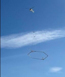
The survey is conducted through a hoop-shaped geophysical device that is towed by a helicopter, and placed into the water.
That hoop is analyzing groundwater underneath the Bay area to see if it’s freshwater or saltwater.
USGS scientists want to know how much salt is in the region’s groundwater, which can affect sea level rise and storm surges.
Learn more about the project from Holly Michael, Director of the Delaware Environmental Institute at the University of Delaware, in a recent article. She’s part of the team analyzing the data. Article link HERE.


